Tuesday, December 8, 2020

BITUMEN, ASPHALT, COAL TAR, CUTBACK BITUMEN

Ever wondered what is Bitumen? What is Asphalt? What is difference between these two? What is MC 30 Bitumen? What is cutback bitumen? We will learn all these in this blog. You can watch YouTube video tutorial here.

Bitumen and Asphalt

ü Asphalt = Aggregate + Bitumen     {In India}

ü Asphalt = Bitumen                           {In America}

So, meaning of Asphalt and bitumen varies according to country as well. Beware where you use this term. We will follow Asphalt = Aggregate + Bitumen throughout this blog.


Bitumen is binding material like cement and Asphalt is obtained by mixing aggregate and bitumen. So, you can say, bitumen is analogous to cement while asphalt is analogous to concrete.


Bitumen vs Coal tar

ü Bitumen is produced from fractional distillation of crude oil (i.e., raw oil or oil in natural state). In fractional distillation, different material distills as different temperature and get separated from mixture.

ü Coal tar is produced destructive distillation of coal and wood in absence of air. Destructive distillation means by burning.

ü Both are black in color.


Requirement of Bitumen

ü Not more sensitive to temperature i.e., should not become too soft or unstable during hottest weather and should not become too brittle causing crack during cold weather.

ü Adequate viscosity at the time of mixing which can be achieved by using cutback bitumen or emulsion bitumen of suitable grades or by heating bitumen and aggregate before mixing.

ü Adequate adhesion i.e., when bitumen is too fluid, it losses adhesion and when bitumen is too viscous, it is adhesive but cannot be applied effectively.


Bitumen as last end product

LPG à Gasoline à Petrol à Kerosene à Diesel à Lubricant à Oil à Wax à Bitumen


As you move towards right, viscosity increases while as you move towards left in the list, viscosity decreases. It means LPG is least viscous while bitumen is most viscous in the above list.


Cutback Bitumen

ü It is a type or grade of bitumen

ü It is liquid bitumen

ü Cutback means reduce something and in Cutback bitumen, Viscosity is temporarily reduced by adding volatile oil

ü After application, the oil evaporates and bitumen gains its original viscosity


Types of Cutback Bitumen

ü If oil is highly volatile then it evaporates quickly and vice-versa. Based on how quickly, the oil evaporates, there are three types-

1.     Rapid Curing (RC)

2.     Medium Curing (MC)

3.     Slow Curing (SC)

The types are described below-

1.     RC à Manufactured by solving bitumen in gasoline. It is recommended for surface dressing and patchwork.

2.     MC à Manufactured by solving bitumen in kerosene. It is recommended for premix with less quantity of fine aggregate.

3.     SC à Manufactured by solving bitumen in Gasoil or fuel oil or directly from distillation of crude oil. It is recommended for premix with appreciable quantity of fine aggregate.

Generally, MC is used in road. So, we will discuss about MC here.


Medium Curing (MC)

ü Now we know that MC-30 is  grade of cutback bitumen.

ü MC-30 means Medium Curing 30. But what does 30 represents here?

ü MC grades are of following types:

Ø  MC-30, MC-70, MC-250, MC-800, and MC-3000

ü The number in grade indicates viscosity. Hence 30 represents minimum viscosity of bitumen.

ü MC grades do not immediately break when comes in contact with aggregate so, it is designed to be mixed with aggregates.

ü Of the above-mentioned grades, we will discuss about MC-30 and MC-70.


MC-30 and MC-70

ü MC-30 has the lowest viscosity

ü MC-70 is commonly used as prime coat

ü MC-30 is used for WBM (Water bound Macadam)

ü MC-70 is used for stabilized soil base/crusher run Macadam

The table below shows viscosity of the above-mentioned grades.


Grade of Cut back Bitumen

Kinematic viscosity at 60oC (140oF) (mm2/s)

Minimum

Maximum

MC-30

30

60

MC-70

70

140

Advantage of Cutback Bitumen

ü Cutback bitumen reduces viscosity so that it can penetrate pavements more effectively or it can be sprayed at cold temperature where neat bitumen cannot be successfully sprayed

ü Penetration grade bitumen has a thermoplastic property which causes material to soften at higher temperature and harden at lower temperature

ü Fluidity of bitumen is obtained by raising temperature but when it is needed to have fluidity at lower temperature, cutback bitumen is employed


Tuesday, November 3, 2020

HOW TO ADD LATERAL STRUCTURE (LEVEE) IN HEC RAS?

Some definitions before adding lateral structure in HEC RAS- 

Centerline: It represents line joining deepest point of the cross-section (i.e. along Thalweg)

Bank line: It separates river and the bank of river

Flow path line: This line represents the center of mass of flowing water

In the channel when drawn at center of mass of water in the channel

Over the left bank when drawn at center of mass of water on LOB

Over the right bank when drawn at center of mass of water on ROB

Flow path line is used to calculate the distance of downstream cross-section of channel, LOB and ROB

Cross-section line: Draw cross-section lines from left to right bank looking in the downstream direction

Download full file by clicking following button.


Click here to watch Video Tutorial


Wednesday, December 25, 2019

HEC RAS 2D UNSTEADY FLOW ANALYSIS

HEC RAS can perform 2D Unsteady Analysis.

Click here to watch Video Tutorial


Download Pdf Tutorial and data of 2D Unsteady flow used in the video.


Sunday, October 20, 2019

HEC GEO RAS

To use HEC GEO RAS, you need to first Pre-processing in ARC GIS along with the extension of HEC GEO RAS.

Then go to HEC RAS. Here you need to run the file by giving necessary inputs.

After completing task in HEC RAS, export the file and import it again in ARC GIS and using HEC GEO RAS, perform the flood mapping.

Refer HEC GEO RAS Video Tutorial here.

(Just Learn Civil doesn't own this PDF)

Monday, August 12, 2019

Elevation-Volume-Area Curve using Surface Volume Tool in ARCGIS


This blog explains how to make Elevation-Volume-Area Curve using Surface Volume Tool in ARCGIS. The curve is useful for making decision in Hydropower project and to design different components along with determining release policy, etc.

Refer Video tutorial here. The link to download the pdf is given at the bottom.

How to write address in python?
Python uses ‘\’ as escape character so it cannot be used in path. Either use ‘/’ or ‘\\’ but if you wish to use ‘\’ in path then put ‘r’ in front of path. Following example illustrates these-

Method 1:
'E:\\HYDROLOGY\\S2\\ArcPY\\OUTPUT'

Method 2:
'E:/HYDROLOGY/S2/ArcPY/OUTPUT'

Method 3:
r'E:\HYDROLOGY\S2\ArcPY\OUTPUT'
r REPRESENTS raw data.

What is ArcPy ?
ArcPy is a python site package. It is used in python to perform data analysis, data management, ect. Hence, ArcPy helps to perform the task of GIS in Python.

In Arc Gis version 10, python version used is 2.6, which is installed with ArcGis.

All you need to do is import ArcPy in python editor and start coding.


How to use Surface Volume tool to find Elevation-Area-Volume Curve?

Requirement:
·      Enable 3D Anlayst as-
Customize | Extension | Check on 3D Analyst

·      GeoPrecessing | Geoprocessing Option…|Check on ‘Overwrite the outputs of geoprocessing operations’
Ø This will append the output data of surface volume to the existing text file.
Ø If this option is not ticked/checked on then error occurs if you try to store multiple data to the same text file.

Steps:
1.  Import DEM of the catchment, in ArcGis, you want to find the curve for
2.  Open Python Console and write Code


3.  For single data (area-volume for one elevation only)
>>>from arcpy import *
* indicates è import everything from arcpy.
Now, Set output file location….
>>>Output = r'E:\AY\S\S2\ArcPY\SurfaceVolume\Volume.txt'
>>>arcpy.SurfaceVolume_3d('cat_dem.tif',Output,"BELOW",1600)
Parameters of Surface Volume Tool-
SN
Parameter
Explanation
1
In_rastersurface
DEM or TIN
2
Out_text_file
Output file location
3
Reference_plane
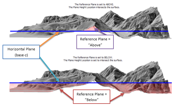
Specify “Above” or “Below” to calculate area/volume above or below the horizontal plane
4
Base_z = elevation to calculate
The horizontal plane above or below which area/volume is calculated

Note: While giving elevation input (base-z), it should be between maximum and minimum elevation value of DEM.


Fig. Figure showing Reference plane and base-z
(Image Source: Arcgis Website)
4. For Multiple data
Use for loop
Syntax: for i in range (start, stop, step):
                     {Write code here}
 Note: Here, replace the elevation data of step 3 with “i” to calculate for multiple elevations
Lets create for 200 m interval from 1800 to 3600
>>> for i in range(1800,3600,200):
...     arcpy.SurfaceVolume_3d('cat_dem.tif',Output,"BELOW",i)

(Here i represents the elevation. Area/Volume is found from elevation of 1800 up to 3400 with 200 interval i.e. 1800, 2000, 2200, 2400, …, 3400)
Why stop=3600 but data is calculated up to 3400 only ??
Note: In python stop value is excluded i.e. 3600 will not be calculated. If you want to calculate for 3600 then use stop value of greater than 3600 like any one of the value as - 3601, 3652, 3700, 3800, etc. (all are greater than 3600 so you can use any of them)

5.  Plot the data in excel or other software…

Final Code:
>>> from arcpy import *
>>>arcpy.SurfaceVolume_3d('cat_dem.tif',r'E:\AY\S\S2\ArcPY\SurfaceVolume\Volume.txt',"BELOW",1600)
<Result 'E:\\AY\\S\\S2\\ArcPY\\SurfaceVolume\\Volume.txt'>
>>> for i in range(1800,3600,200):
...     arcpy.SurfaceVolume_3d('cat_dem.tif',r'E:\AY\S\S2\ArcPY\SurfaceVolume\Volume.txt',"BELOW",i)

Output:
Dataset, Plane_Height, Reference, Z_Factor, Area_2D, Area_3D, Volume
..rcPY\SurfaceVolume\cat_dem.tif, 1800.00, BELOW, 1.000000, 2386036360.9595, 2737722134.2743, 1292870451541.2
..rcPY\SurfaceVolume\cat_dem.tif, 2000.00, BELOW, 1.000000, 2751422471.6363, 3163428393.3652, 1808497318967.5
..rcPY\SurfaceVolume\cat_dem.tif, 2200.00, BELOW, 1.000000, 3028033578.3525, 3487425353.1481,  2387809023310
..rcPY\SurfaceVolume\cat_dem.tif, 2400.00, BELOW, 1.000000, 3229310550.9426, 3724084680.6395, 3014856120712.8
..rcPY\SurfaceVolume\cat_dem.tif, 2600.00, BELOW, 1.000000, 3367325890.0696, 3886617696.2116, 3675457721085.6
..rcPY\SurfaceVolume\cat_dem.tif, 2800.00, BELOW, 1.000000, 3453274628.7979, 3987641478.238, 4358511131963.1
..rcPY\SurfaceVolume\cat_dem.tif, 3000.00, BELOW, 1.000000, 3504734282.3825, 4048058015.2732, 5054687151193.3
..rcPY\SurfaceVolume\cat_dem.tif, 3200.00, BELOW, 1.000000, 3541936569.2609, 4091009563.4753, 5759568714963.8
..rcPY\SurfaceVolume\cat_dem.tif, 3400.00, BELOW, 1.000000, 3563171917.2772, 4115247120.6426, 6470475092432.7

Area2D = Projected Area

Area3D = Surface Area
Elevation vs Area curve

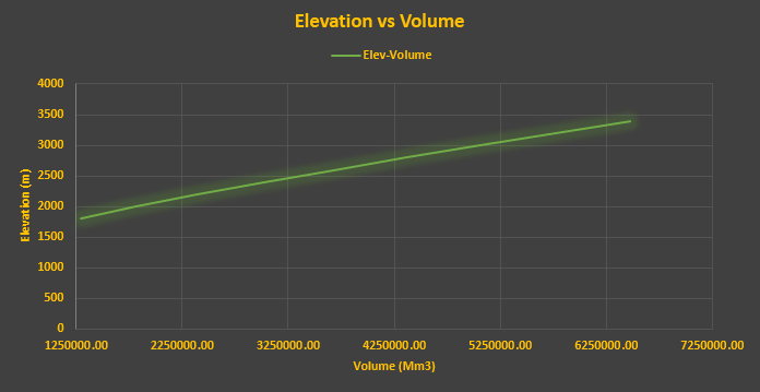
Elevation vs Volume curve


MOST RECENT

BITUMEN, ASPHALT, COAL TAR, CUTBACK BITUMEN

Ever wondered what is Bitumen? What is Asphalt? What is difference between these two? What is MC 30 Bitumen? What is cutback bitumen? We wil...